

The site
The site is situated to the far north-east boundary of the Midlothian Council area, bordering the City of Edinburgh Council to the immediate north and East Lothian Council to the east.
It comprises around 2.9 hectares of land and forms the south-eastern plot of the Whitehill Mains development site (which extends to around 17 hectares), which benefits from Planning Permission for a range of uses.
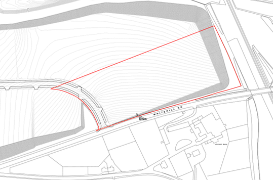
Site location plan
Click on the above image to view

Site context plan
Click on the above image to view
The site is bound:
-
to the north by undeveloped land – part of the same wider development site – beyond which lies the A1 and Newcraighall Train Station and Park and Ride
-
to the east by the train line, undeveloped land, and the A1
-
to the south by Whitehill Road, agricultural land including farmer dwellings, alongside Millerhill Energy Centre and Zero Waste Facility
-
to the west by undeveloped land, part of the same wider development site
Connectivity and access
A recently constructed formal vehicular access runs along the western boundary of the site from Whitehill Road in the south to Fort Kinnaird retail and trade park in the north-west.
A pedestrian footpath runs along the northern boundary of the wider development site adjacent to the public roadway. To the southeast there is a pedestrian route which runs under the A1 and connects to the national cycle network (Route 1).
The site is well located close to existing and emerging communities, including Danderhall, Shawfair, Musselburgh and Newcraighall. It is also within walking and cycling distance of Queen Margaret University and Fort Kinnaird Retail Park.
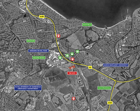
Wider site context plan
Click on the above image to view